Talking 3D maps facilitate navigation for the blind, everyone else
Ever felt completely turned around on a sprawling college campus? How about at a museum with seemingly endless rooms and corridors?
Now imagine trying to navigate those real-world mazes without the use of sight to guide your way. That’s a challenge faced every day by people with visual impairment.
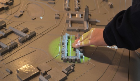
One of the 3D, talking maps from Touch Graphics. From the University at Buffalo.
Fortunately, there’s a burgeoning blend of design and technology that’s poised to make navigation a whole lot simpler — regardless of whether or not you have the use of sight. Sydney Brownstone recently reported on this fascinating creation for Fast Company’s Co.Exist.
We’ve all seen tiny, scaled 3D models of architectural developments or landscapes. A company called Touch Graphics, based out of Maryland, is using that idea to create interactive, 3D maps. Touch Graphics is working with the University of Buffalo’s Center for Inclusive Design and Environmental Access (IDeA Center) to bring these installations to life.
These aren’t like the bumpy topography maps of your grammar school days. These high tech maps allow users to explore with their hands, and the most updated model of the map responds by orienting the users with audio cues when they touch a certain building or landmark.
The newest maps do much more than sound out the name of a building when you touch it. It can actually tell you what type of building it is, and even provide a directory of people or businesses inhabiting the space.
If you’re thinking that the idea sounds useful for anyone — not just those with visual impairments — you’re not alone. These maps are far more interactive, functional, and — for many of us — helpful than traditional maps. After all, we live in a 3D world, so why shouldn’t signs that help us navigate that world be 3D as well?
IDeA Center researcher Heamchand Subryan confirms that, while the maps were originally designed for visually impaired people, that’s not their only market at this time. “I see the maps being used in a lot of different places besides a center for the blind or a school for the blind,” he says. “They can be used by everyone.”
In fact, The Perkins School for the Blind (Helen Keller’s alma mater) has a tactile map that includes an overhead projector that can broadcast aerial views from Google Earth directly onto the map. This added functionality for sighted users “goes to the heart of the model’s inclusive mission,” Brownstone said.

